 
The Rural Planning Wheel Agriculture Zone The primary objective of the agriculture zone is as its title suggests to preserve existing agricultural production and to allow for new agricultural production in appropriate locations by recognising the importance of high quality agricultural land. The methodology has been applied to outline the parameters to be considered and the constraints, which need to be recognised when assessing and identifying land suitable for an agricultural production zone. This land is generally high-class agricultural land being that land which is known as prime crop and pastoral land. This includes classes 1-3 of the agricultural land classification technique as used by NSW Agriculture as described in the Rural Land Evaluation Manual published by the NSW Department of Urban Affairs and Planning. However, some of the production areas have class 4 land in it, which may be needed in a particular agricultural system. Having regard to the varying nature of landforms, it is not always possible to have all land in the agriculture zone as high-class land. It is inevitable that some of the land will not be high class. However, as the objective is to preserve the existing agricultural production, and the landforms vary, it is legitimate to have some non-high class land in the zone. It may also be possible that the production in the zone does not require high-class land. This is so for non-soil based agriculture such as intensive livestock (poultry) and hydroponics. A secondary objective of the agriculture zone is to reduce the incidence of rural land use conflict. Ensuring that any new dwelling houses within the zone are permitted only in conjunction with a legitimate and sustainable agricultural enterprise does this. Likewise, any agricultural enterprise, which is proposed for land adjacent to an existing dwelling house, which is used for residential use, will have to take into consideration the use of the land for residential purposes and provide steps to reduce potential conflict. The photograph below shows an aerial view of the agriculture zone. It is important to note that the zone boundary is not a road or lot boundary, as is the normal practice when delineating zone boundaries. The land on the left-hand side of the photo is a rural residential zone and is considerably higher (100m) than the land used for agriculture. To ensure that rural land use conflict is avoided, the zone boundary is in the tree line at the base of the slope. This and the physical separation of the land uses will ensure that the integrity of the zone is maintained. The minimum subdivision size within the agriculture zone should be based on an analysis of the lot sizes and land uses. The minimum should be related to the size of existing holdings used for soil-based agriculture and the lack of rural residential uses at this size. The proponent should also satisfy the Council that the subdivision is required for a sustainable agricultural purpose and as such a Total Farm Management Assessment should be required. This includes a Property Plan, an Agricultural Sustainability Assessment and a Farm Management Statement. 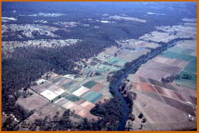 Top of page... |
|
|| Rural Planning Wheel || launched March, 1999 http://www.ruralplanning.com.au/ |
|